Page content
Basic Information
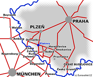
With the population of 23.000 Klatovy is the second largest town of the Plzen region. The town of Klatovy lies near to the south-western border of the Czech Republic with the Federal Republic of Germany just off the international road E 53. The town spreads over 81 km and with its 23 thousand inhabitants it represents the largest settlement within the Klatovy region. There are two railway lines crossing the town, the Plzeň-Klatovy-Železná Ruda line and Horažďovice-Klatovy-Domažlice line.
|
|
Altitude: 405 m above sea level
Number of inhabitants: 22 233 (1.1.2019)
Administrative area: 80,67 km2
GPS : 49°23'43.876"N, 13°17'42.197"E
Town quarters:
Beňovy, Čínov, Dehtín, Dobrá Voda, Drslavice, Habartice, Chaloupky, Kal, Klatovy I, Klatovy II, Klatovy III, Klatovy IV, Klatovy V, Kosmáčov, Křištín, Kvaslice, Kydliny, Lažánky, Luby, Otín, Pihovice, Sobětice, Štěpánovice, Střeziměř, Tajanov, Točník, Tupadly, Věckovice, Vícenice, Vítkovice


